Upon arriving in Kamikochi (my base for the Japanese Alps) there appeared to be two types of hikers – the leisurely, flat along the river walker, and full blown mountain climbers, with ice axe, crampons etc. Being comfortably in the middle of these two categories I went in search of a middle of the road hike.
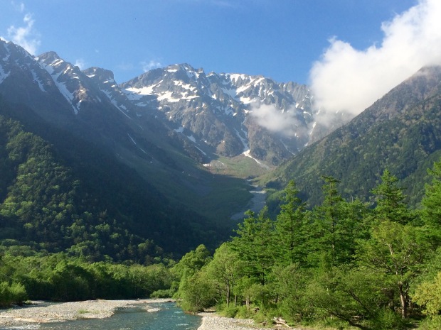
The beautiful Japanese Alps
In the end I decided to walk from Kamikochi to the Nishi Hotaka Hut (2367m), and back. The only information I could find online about this route (in English) was from people hiking down, after taking the Shin Hotaka ropeway up the other side. Generally people said the descent was fine, and as I’m better with up than down I decided to go for it.
How To Get To The Trail
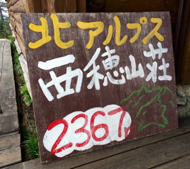
From Kamikochi bus station walk toward the river and turn left (toward Taisho Pond). Walk until you reach the Hotaka Bridge, and cross. From here you will see the sign pictured below, and this leads you straight to the trail.
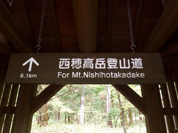
If you see this sign you’re on the right trail
The Trail
The trail is fairly well maintained, with built in steps, which really helps a lot with the descent. The route up starts relatively flat, before climbing fairly steeply. You are walking through the forest and there are lots of tree roots, so keep your wits about you.
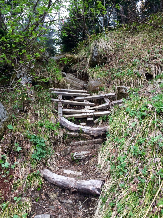
There are steps in places, but they can be a bit wonky!
About halfway the route flattens, as you walk along the saddle. Afterward the steep ascent continues. Then came the biggest surprise – snow! And a fair bit of it. I hiked in the end of May, which isn’t the peak trekking season, but as I wasn’t going too high I thought snow wouldn’t be a problem. Thankfully it was negotiable in decent hiking boots, and there is a fixed rope to hold onto if you really struggle.
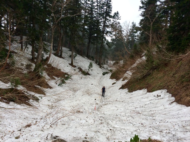
This part of the hike is a mixture of snow and boulders, but it isn’t too difficult to reach the hut. In total the route took two and half hours from the sign up to the hut. And then two hours back down afterwards.
Following The Route
The route is easy to follow, with regular signs. Although these are all in Japanese, so it’s worth taking a picture of the symbols in the visitors centre before setting out. There are also ribbons on poles, which are particularly helpful in the snowy section.
There is only one junction, and you want to go right and head upwards. Rather than straight ahead. This is signposted so check the symbols if you’re unsure.
The View
Unfortunately despite my efforts the view was hidden by cloud. A bit of a disappointment, but generally the view from the hut, and nearby ridge is meant to be rather impressive. So if you go on the clear day I’m sure you’ll be happy.
At the hut
Things To Note:
▪️Wear a bear bell! I saw lots of Japanese trekkers with these the day before and had no idea why they were jingling. Later I saw a sign about bears, and that one had been sighted that week. After that I made sure I jingled too!
▪️Although the route does not go particularly high, there may be snow outside of peak trekking season. Be prepared and take sturdy, waterproof boots. Also be willing to turn back if it gets too sketchy.
▪️I stayed in a ryokan before hiking, which provided dinner and breakfast. Although this was nice food, it wasn’t really trekking food in my book. And I struggled more than usual until I tucked into a jam pastry. There also isn’t anywhere to buy good trekking snacks in the area, so bring some with you to Kamikochi.
▪️Make sure you take enough water and sports drinks with you on the hike. The sports drinks can be bought in Kamikochi.
▪️Take rain gear and warm clothes in case the weather turns bad.
I would recommend the hike to anyone whose interested in trekking in the Japanese Alps, but hasn’t got the equipment/experience to go up to the summits. It’s certainly a bit more adventurous than the typical day hikes from Kamikochi, and you don’t have to pay for the rather expensive rope way. Fingers crossed you have better views than me!
If you enjoyed this blog post please consider sponsoring me to say thank you 🙂
http://www.justgiving.com/fundraising/cathylafrenais


I’m off to Japan in a little over 5 weeks… AND YOU’VE MADE ME MORE EXCITED THAN EVER! Gorgeous pictures, thanks for the tips. 🙂
LikeLiked by 1 person
Thank you 🙂 I’m sure you’ll love Japan. It’s been one of my favourite countries! Enjoy.
LikeLiked by 1 person
I love the “doing being becoming” title!
LikeLiked by 1 person
Thank you 🙂 it’s from Occupational Therapy theory.
LikeLiked by 1 person
Love
LikeLiked by 1 person
Beautiful pictures! And so helpful too…makes me want to visit Japan 😊
LikeLiked by 2 people
Thank you 🙂 you should definitely go. It’s a truly beautiful place.
LikeLiked by 1 person
Thanks for stopping by.
Forensic mental health seems challenging.
Happy trails.
LikeLiked by 1 person
Thank you 🙂 and yes it can be very challenging. But also incredibly interesting and rewarding!
LikeLike
That’s awesome! I climbed Mount Fuji amd have been craving some more Japanese hiking/mountain climbing ever since. Awesome post!
LikeLiked by 1 person
Wow. What was climbing Fuji like? I really wanted to climb but it wasn’t the right season. Will definitely be back to do it some point. The Japanese Alps are beautiful and well worth a visit!
LikeLike
Nice! I’ve been reading A Walk in the Woods by Bill Bryson and Wild by Cheryl Strayed and both are making me crave some serious mountain range hiking 🙂
Fuji was an incredible experience – I hadn’t trained for it at all though and the physical exertion was strenuous, especially because of the altitude (I got some major altitude sickness around 3000 meters). I also did the overnight hike (10pm to 6am) so I could make it to the top to watch the sunrise, and that was…intense 😛 But ultimately in a good way. It was unforgettable. Highly recommend it.
LikeLiked by 1 person
Sounds tough but amazing. Altitude always makes things so much difficult. My boyfriend struggles with altitude, but I’m one of the lucky ones who doesn’t. I’ve written a post about altitude sickness if you’re interested.
Wild is a great book. I haven’t read the other one, will have to check it out. Thanks for sharing your Fuji experience 🙂
LikeLiked by 1 person
No problem! Nice to connect with another hiker 🙂 And I’d be very grateful if you could link me that post actually 😉 might come in handy some day.
LikeLiked by 1 person
Here it is: https://doingbeingbecoming.com/category/trekking/altitude-sickness/ I hope it’s useful 🙂
LikeLiked by 1 person
Thanks! I’ll read this on the way to work 🙂
LikeLiked by 1 person
Great tips and great pics!
LikeLiked by 1 person
Thank you 🙂
LikeLike
Kamikochi is definitely in my bucket list for next summer! That place seems to be so beautiful 🙂
LikeLiked by 1 person
It really is. The views are stunning! I’m planning to write another post about Kamikochi itself in the near future, which might be helpful.
LikeLiked by 1 person
Please do! Looking forward to it 🙂
LikeLiked by 1 person
Sounds a bit tricky, but do-able. I’d love to visit Japan but the chances aren’t great.
Many thanks for the follow. Would you be ok with me including this in my shared walks on the next Jo’s Monday walk? I like to showcase variety, where I can.
LikeLiked by 1 person
If you do get the opportunity you really should visit. It’s a wonderful country 🙂
And yes of course. That’s absolutely fine.
LikeLike
Great! Will do 🙂
LikeLiked by 1 person
I came across a monument to the Rev Walter Weston, north of Toyama, hailed as the 19th century father of alpine climbing in Japan. Fascinating guy……but you probably know about him already. https://en.wikipedia.org/wiki/Walter_Weston
LikeLiked by 1 person
Thank you for sharing. I saw the memorial for him along the river. Interesting stuff!
LikeLike
I discovered your blog from Jo’s Monday Walks – so glad I did! I look forward to reading more about your adventures! Best, Susan
LikeLiked by 1 person
Thank you! Lovely to hear you’re enjoying my blog 🙂
LikeLiked by 1 person
Love your photos! Especially the one of the wonky steps 🙂
LikeLiked by 1 person
Thank you! And yes those wonky steps sure we’re interesting!
LikeLike
ooooo…..this looks A-mazing! I wanttogotothere. 🙂
LikeLiked by 1 person
It was great fun! Would definitely recommend it 🙂
LikeLike
Nice hike! We hiked for three days from there all the way to the summit of Yari Dake, sleeping in our tent and conquering the famous Daikiretto ridgeline. This area of Japan was truly magnificent and inspiring. We had less snow on the trail compared to you though! 🙂
LikeLiked by 1 person
Your multi day hike sounds awesome. What time of year did you go? I’d definitely like to go back, it’s such a lovely place 🙂
LikeLiked by 1 person
It was awesome indeed. We went in early August. Feel free to read our article with tips and camping spots (the huts need to be booked one year prior but camping is easier). We tracked the hike as well to give you an idea of the elevation difference. Have a good one! https://bestregardsfromfar.com/2015/08/14/hiking-japanese-alps/
LikeLike
Lovely post and photos! Wish I can hike in japan one day! I’ve also started blogging my hikes in Hong Kong recently, it’ll be great if you can check it out 🙂 http://www.hjkhiking.wordpress.com
LikeLiked by 1 person
I lived in Kanazawa for a few years, its about 80 miles west of Kamikochi and well worth a visit. There are three holy mountains in Japan, Mount Fuji, Hakasan and Tatayama. Hakusan and Tatayama are within the Japanese Alps and have truly amazing views, with many onsens (hot springs) along the way, great for tired limbs!
LikeLiked by 1 person